

“How Digital Crop Surveys Are Revolutionizing Land Records and Empowering Rural Farmers”
Digital Crop Survey and Land Record Modernization: How Technology Is Transforming Rural Governance and Agricultural Financing in Central India
Byline: Written by Tej Kumar Sahu for tej24.com
Category: Governance / Agriculture / Rural Economy
Publication Platform: tej24.com
Executive Overview: A Paradigm Shift in Ground-Level Governance
Across rural districts in India, ground-level administrative machinery is undergoing a structural digital transformation. Traditional paper-based land assessment, manual revenue surveys, and physical crop verification processes are systematically being phased out. In their place, a synchronized digital framework—combining high-resolution GIS mapping, real-time GPS tagging, handheld Mobile App-based surveys, and unified digital Nazul land management—is being implemented across local administration zones.
This transition represents more than a simple technological upgrade. It directly impacts how government subsidy distributions, crop insurance payouts (under Pradhan Mantri Fasal Bima Yojana), digital Nazul lease renewals, revenue record corrections, and emergency disaster relief allocations function at the grassroots level. Local administrative teams, including district collectors, land revenue officers (Tehsildars and Patwaris), and agricultural development officers, are executing field inspections to audit these systems on the ground.
This detailed investigation by tej24.com analyzes the operational mechanisms, ground realities, procedural workflows, structural benefits, and administrative challenges of India’s evolving digital land and agricultural architecture.
Part 1: The Architecture of Digital Crop Survey (DCS)
1. The Historical Bottlenecks of Manual Surveys
For decades, agricultural yield assessment and land crop identification relied on the physical inspection system known as “Girdawari.” Under this traditional framework:
Patwaris physically visited fragmented land parcels across multiple villages.
Records were manually penned into ledger registers (Khasra registers).
Human error, procedural delays, and dispute vulnerabilities frequently delayed financial compensation during crop damage events.
Marginal farmers suffered the most, often lacking verified proof of crop sowing when seeking institutional bank credit or minimum support price (MSP) sales.
2. How the Mobile-Based Digital Crop Survey Works
The newly deployed Digital Crop Survey (DCS) system replaces subjective manual notes with geo-fenced digital data entries:
[Field Agent / Mobile App] ──> [GPS Tagged Photo] ──> [GIS Map Overlay] ──> [Revenue / Agritech Database Verification]
Geo-Fenced Verification: Field surveyors must stand physically within the boundaries of the specific agricultural plot (Khasra number) to submit survey data. The application uses satellite-derived GPS coordinates to lock the submission location.
Photographic Evidence with Time-Stamps: Surveyors capture real-time images of the standing crop. The system automatically timestamps and embeds spatial coordinates into the photo file.
Crop Type Identification: The data includes precise crop varieties (e.g., Kharif paddy, pulse varieties, oilseeds) and the exact percentage of land plot utilized for cultivation versus fallow land.
Direct Integration with Revenue Portals: Survey entries are automatically synced with the state revenue database, eliminating double-entry clerical mistakes.
Part 2: On-the-Ground Execution and Administrative Spot-Audits
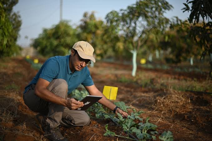
To evaluate system accuracy, senior district authorities are conducting live field spot-checks. Recent administrative drives across several agricultural belts have seen Collectors, Sub-Divisional Magistrates (SDMs), and Tehsildars walking into crop fields alongside farmers to cross-examine digital application entries against real crop growth.
Field Audit Workflow Observed During District Operations
Random Sampling Selection: Administrative officers select Khasra numbers at random across various Gram Panchayats.
Real-Time Data Cross-Matching: Officers pull up the mobile survey portal on site to verify whether the recorded crop matches the crop growing in the field.
Rectification of Discrepancies: If a discrepancy exists—such as a plot recorded as fallow when pulse crops are standing—immediate instructions are issued to the local Revenue Inspector and Patwari to correct the entry on the spot.
Direct Farmer Engagement: Authorities interact with local cultivators to ensure they have received confirmation notifications and that their Aadhaar-linked land entries are accurate.
Direct field verification prevents fraudulent claims, ensures transparent crop loss evaluation during unseasonal rains or pest infestations, and speeds up insurance claim settlements.
Part 3: Modernizing Land Ownership – The Digital Nazul System
Alongside rural crop surveys, urban and semi-urban land administration is receiving a similar digital overhaul through the E-Nazul Management System.
What is Nazul Land?
Nazul land refers to government-owned property historically leased out for residential, commercial, or institutional purposes for set tenures (typically 30 years or 90 years).
Key Upgrades Introduced by E-Nazul Systems:
Online Lease Renewal Applications: Citizens no longer need to physically visit district collectorates or land revenue offices multiple times. Lease renewal applications can be filed digitally within minutes via mobile or computer.
Transparent Lease Rent Calculation: Automatic digital calculators estimate lease renewal fees, penalties, and ground rent based on standardized government land value circles, eliminating arbitrary fee estimations.
Digital Map Boundary Verification: High-precision drone mapping and satellite overlays define lease plot perimeters, eliminating encroachments and boundary disputes between adjacent plot holders.
Digitally Signed Lease Certificates: Once approved by competent revenue courts or collectorate departments, lease extensions receive encrypted, QR-coded digital signatures, downloadable directly by citizens.
Part 4: Impacts on Institutional Credit, PM-KISAN, and Disaster Relief
The unification of digital land records (Bhuiyan / Bhulekh platforms) and digital crop survey data creates a single, reliable point of truth for various government departments and financial institutions.
| Administrative Domain | Traditional Manual Process | Digital Survey & E-Land Framework | Direct Impact on Citizens |
| Kisan Credit Card (KCC) | Required paper submissions, Patwari verification, and physical land search certificates. | Banks pull verified land & crop data directly via secure API integrations. | Loan approval timeline reduced from weeks to days; eliminates middleman fees. |
| PM-KISAN Disbursement | Risk of invalid bank account linkages, duplicate entries, or deceased beneficiary claims. | Mandatory e-KYC linked with digitized land parcel ownership data. | Prevents leakages and guarantees funds reach genuine landholders. |
| Crop Loss Assessment | Manual eye-estimation by relief committees; long delays in processing compensation. | Satellite verification combined with geo-tagged crop damage photos. | Rapid disbursal of insurance compensation directly into bank accounts (DBT). |
| Procurement at MSP | Paper tokens; risk of illegal crop transportation from outside regions. | Sowing registration tied directly to verified digital crop survey plots. | Genuine farmers get fair price support; stops unauthorized crop dumping. |
Part 5: Overcoming Challenges in Grassroots Implementation
While the benefits of digital agriculture and land management are vast, transitioning a massive, diverse rural population to modern digital tools presents challenges:
1. Internet Connectivity Gaps in Remote Regions
In forested or topographically isolated Gram Panchayats, mobile network coverage can be spotty. To counter this, digital crop survey applications are built with offline caching capability: field workers capture geo-tagged photos offline, and the data automatically syncs once the device enters a network zone.
2. Digital Literacy Among Smallholder Farmers
Many elderly or illiterate farmers struggle to navigate online portals. District authorities are deploying Gram Rozgar Sewaks, Common Service Center (CSC) operators, and local Mitras to assist farmers in verifying their online records without charging unauthorized fees.
3. Resolving Historical Land Record Discrepancies
Decades-old land division disputes, unrecorded inheritance transfers (Namantaran), and missing field maps require human intervention before digital locking. Revenue departments are conducting specialized Revenue Camps (Jan Samasya Nivaran Shivir) at the Panchayat level to resolve long-standing mutation cases on the spot.
Part 6: Future Roadmap – AI, Satellite Integration, and Smart Agriculture
The digital crop survey is the foundation for an integrated agri-tech ecosystem in India:
Artificial Intelligence for Pest Detection: Future updates to digital crop applications aim to incorporate AI image analysis. When a surveyor or farmer uploads a photo of a crop, AI algorithms will detect early pest infestations or nutrient deficiencies and suggest localized solutions.
Drone-Based Yield Estimation: State agricultural departments are combining ground-level digital crop surveys with high-resolution drone imagery to calculate precise yield expectations, helping state governments plan storage logistics and grain exports.
Climate-Smart Risk Management: Granular crop mapping data enables micro-level weather advisory services. Farmers can receive targeted SMS alerts regarding weather risks, crop management recommendations, and harvesting timelines tailored to their specific land plot.
Conclusion: A Model for Governance and Transparency
The ongoing integration of Digital Crop Surveys, modern land record digitization, and streamlined administrative oversight represents a major step forward for rural Indian governance. By taking technology directly to agricultural fields and introducing transparent E-Nazul services, local administrations are eliminating administrative bottlenecks, protecting farmer rights, and ensuring public schemes reach their intended beneficiaries without delay.
As field spot-audits continue and digital infrastructure expands to cover every village, this transparent framework serves as a model for public service delivery, fiscal efficiency, and agricultural empowerment.



One thought on ““How Digital Crop Surveys Are Revolutionizing Land Records and Empowering Rural Farmers””